Land Ownership in Newry and Mourne
Lease from the Marquis of Downshire to Edward Rhames Courtney of premises in Hill Street, Newry, 1st January 1814
In the 1690s, the Hill family bought the townland of Carneyhough, on the west and north sides of the town of Newry, from the Crilleys.
Originally known as The Low Ground, part of this area was formally laid out during the 18th century to form Hill Street. Trevor Hill and Kildare Street were also developed at this time.
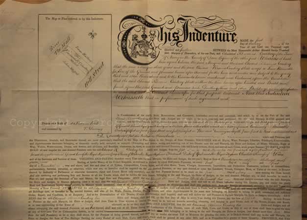
Lease, Newry 1814
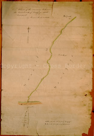
Derryoge and Dunavil, 1843
This indenture between the Marquis of Downshire and Edward Rhames Courtney is an example of a number of leases made for Hill Street in which the leasee was obliged to erect a dwelling and other buildings on the land leased.
Courtney's property lies between Hill Street and The Mall. Its dimensions are given as 48 feet on the Hill Street frontage, 49 feet on the rear and 178 feet in depth.
Plan of the Mearing between the townlands of Derryoge and Dunavil, 1843
Mearings are boundaries between landed estates or townlands. They can be either man-made (plantations or marker stones) or natural features. Mearings were often the subject of disputes between landlords who held adjacent estates or their tenants.
The 'Mears and Bounds' of the Earl of Kilmorey's Mourne Estate in the parish of Kilkeel and the Ross family's estate in the parish of Kilbroney were established in 1828.
In coastal districts landlords were able to claim the foreshore between the high and low watermarks. This map appears to have been drawn as the result of a dispute over the exact location of the mearings on the foreshore between the townlands of Dunavil and Derryoge.
Ownership of the foreshore was important on this part of the county Down coastline because of the 'wrack' or seaweed harvest. Seaweed was an important source of fertilizer on farms in the area.
On the map, the "mearing by Derryoge men" is marked by a series of stones, while the "mearing by Dunavil men" is marked by a "broadstone" on the east side.
Next page - Magheramurphy 1846, Ballynagholy 1914 » « Previous page - Lease 1715, Ballinacraig 1784
- home |
- about project |
- online catalogue |
- online exhibitions |
- activities |
- oral history collection
- about us |
- contact us |
- legal |
- acknowledgements
© Cross Border Archives Project . Website design and development by morsolutions.
This project is part financed by the European Union through the Interreg IIIA Programme managed for the Special EU Programmes Body by the East Border Region Interreg IIIA Partnership.
![]()
